Markus Castro
What Is the Manila Trench? Understanding Earthquake and Tsunami Risks in the Philippines
Table of Contents
The Philippines is no stranger to earthquakes. Located along the Pacific Ring of Fire, the country experiences frequent seismic activity caused by tectonic plates moving beneath and around the archipelago. While many earthquakes are relatively minor, some geological structures can generate much stronger events.
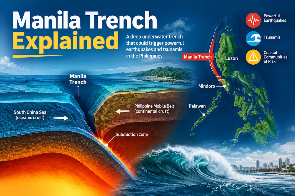
One is the Manila Trench, an underwater geological formation west of Luzon.
Although most Filipinos may not be familiar with this offshore structure, scientists have been studying it because it could generate powerful earthquakes and tsunamis. A major earthquake along the Manila Trench could affect coastal communities facing the West Philippine Sea, and some studies also examine the possibility of tsunami waves reaching Manila Bay.
Naturally, this raises several questions. How powerful could an earthquake along the Manila Trench become? Which Philippine provinces could be affected by a tsunami? Could waves reach Metro Manila? And how much time would residents have to get to safety?
Researchers have explored several possible earthquake scenarios, including hypothetical events measuring magnitude 8.5, 8.8, and even magnitude 9 or higher. These scenarios help scientists understand the potential hazards and improve disaster preparedness.
However, earthquake scenarios are not predictions. Scientists cannot determine exactly when a major earthquake will happen or how powerful it will be.
Understanding the Manila Trench is not about creating unnecessary fear. It is about understanding the risks, recognizing warning signs, and ensuring communities are prepared.
What Is the Manila Trench?
The Manila Trench is a deep underwater depression in the South China Sea, west of Luzon. It forms along an active tectonic boundary where one section of the Earth’s crust moves beneath another in a process called subduction.
To understand why this matters, it helps to know how trenches form.
The Earth’s outer surface is made up of enormous sections called tectonic plates. These plates are constantly moving, although their movement is usually too slow for people to notice.
When two plates converge, one may gradually sink beneath the other. Over millions of years, this downward movement creates a deep depression on the ocean floor known as an oceanic trench.
The Manila Trench marks part of the boundary where oceanic crust associated with the South China Sea moves beneath the Philippine Mobile Belt.
This geological process is important because subduction zones can generate powerful earthquakes. If a large section of the boundary suddenly slips, the movement can release enormous amounts of energy.
When this happens beneath the ocean, it may also disturb the seafloor and displace seawater, potentially generating a tsunami.
The Manila Trench therefore deserves attention not simply because of its depth or size, but because of the earthquake and tsunami hazards associated with the geological system.
Where Is the Manila Trench Located?
The Manila Trench runs generally from south to north along the western side of Luzon, facing the South China Sea, also referred to as the West Philippine Sea in Philippine geographic and public usage.
Its southern section lies near waters west of Mindoro, while its northern extent approaches southwestern Taiwan.
Because of its location, several Philippine coastal areas are relevant when discussing possible Manila Trench earthquake and tsunami scenarios.
These include:
- Ilocos Region: Coastal communities in Ilocos Norte, Ilocos Sur, La Union, and Pangasinan.
- Central Luzon: Coastal areas of Zambales and Bataan.
- Metro Manila: Communities along the Manila Bay coastline.
- Mindoro: Coastal settlements in Occidental Mindoro and Oriental Mindoro.
- Palawan: Communities along the western coastline facing the South China Sea.
Not all these places would experience the same level of danger. Their exposure depends on the earthquake’s location, the tsunami’s direction and strength, coastal elevation, and the shape of the surrounding seabed.
For example, a low-lying coastal village may face a different level of exposure from a community located on elevated ground, even if both are in the same province.
This is why residents should check local tsunami hazard maps rather than assume every coastal area faces the same threat.
How Was the Manila Trench Formed?
The Manila Trench developed over millions of years as tectonic plates moved.
West of Luzon, oceanic crust associated with the South China Sea portion of the Sunda Plate system converges with the Philippine Mobile Belt. As the oceanic plate moves eastward, it sinks beneath the overriding plate.
This process is known as subduction.
As the descending plate bends downward, it creates a deep depression on the ocean floor. Over geological time, continued movement has helped shape the Manila Trench and the surrounding underwater landscape.
Subduction also plays an important role in earthquake and volcanic activity. Stress builds up as plate boundaries interact, while changes within the descending plate and surrounding mantle contribute to other geological processes.
The Manila Trench is therefore part of a much larger tectonic system that influences the geological activity of the western Philippines.
Why Can the Manila Trench Generate Powerful Earthquakes?
Scientists are mainly interested in the Manila Trench because it can generate large earthquakes.
At a subduction zone, two tectonic plates move toward each other. However, their boundary does not always slide smoothly. Friction can lock sections of the boundary even as the plates continue moving.
Over time, stress builds up along these locked sections.
Eventually, the stress may become strong enough to overcome the friction holding the plates together. When a section suddenly slips, the stored energy is released through seismic waves. This is what produces an earthquake.
When a large portion of a subduction-zone boundary ruptures, the resulting earthquake is called a megathrust earthquake.
The Manila Trench is considered a potential source of this type of earthquake.
However, not all earthquakes in the region originate from the same geological structure. Some occur within the descending plate, while others may originate in the overriding crust or along nearby faults.
Scientists study earthquake locations, depths, and movement patterns to better understand the region’s seismic activity.
It is also worth remembering that increased earthquake activity does not automatically mean a major earthquake is about to happen. Earthquakes cannot currently be predicted with enough precision to identify an exact date or time.
How Strong Could a Manila Trench Earthquake Become?
One of the biggest questions surrounding the Manila Trench is how powerful an earthquake it could potentially generate.
A 2019 study published in Natural Hazards and Earth System Sciences, titled Revised Earthquake Sources Along Manila Trench for Tsunami Hazard Assessment in the South China Sea, examined the trench’s geological characteristics and possible earthquake rupture scenarios.
The researchers identified three potential rupture segments:
- 14 to 16 degrees north
- 16 to 19 degrees north
- 19 to 21.7 degrees north
Their analysis suggested these segments could generate earthquakes of magnitude 8.5 or greater, with some modeled scenarios reaching magnitude 9 or higher.
The study also considered the possibility of a large earthquake releasing accumulated tectonic strain over an assumed 1,000-year seismic return period.
This figure should not be interpreted as a schedule. It does not mean that a major earthquake will happen every 1,000 years or that the next one is approaching.
Instead, the researchers used geological assumptions to explore how much energy could potentially be released under different rupture scenarios.
Could the Manila Trench Produce a Magnitude 9 Earthquake?
A magnitude 9 earthquake is an extremely powerful event. Earthquakes of this size can affect vast areas and generate destructive tsunamis when they occur beneath the ocean.
Two well-known examples demonstrate their potential impact.
The 2011 Tohoku earthquake in Japan measured magnitude 9.0 and triggered a devastating tsunami that destroyed coastal communities and damaged critical infrastructure.
The 2004 Sumatra-Andaman earthquake, estimated at magnitude 9.1 to 9.3, generated a massive Indian Ocean tsunami that affected several countries.
These disasters explain why scientists closely monitor major subduction zones.
Research on the Manila Trench has explored similar earthquake magnitudes to understand what could happen if a large section of the fault system ruptures.
However, this does not mean that a magnitude 9 earthquake is certain to happen along the Manila Trench.
Scientists still have questions about the fault’s segmentation, how much of the boundary is locked, and how much tectonic stress has accumulated.
The important distinction is that a magnitude 9 earthquake is a possible scenario considered in scientific research, not an official prediction.
Could the Manila Trench Generate a Major Tsunami?
Yes. A powerful earthquake along the Manila Trench could potentially generate a tsunami if it causes sudden vertical movement of the seafloor.
When a large section of the ocean floor rises or sinks, it pushes or pulls the water above it. This displacement creates waves that travel outward from the earthquake source.
Unlike ordinary waves caused by wind, tsunamis involve the movement of large volumes of water throughout the water column.
They can travel across deep oceans at considerable speeds. As they approach shallow coastal waters, their speed decreases while their height may increase.
Another important thing to remember is that a tsunami is rarely just one wave.
Several waves may arrive over an extended period, and the first one is not necessarily the largest. Powerful currents may continue affecting coastal areas long after the initial wave has passed.
A 2019 study by Qiu and colleagues modeled different earthquake scenarios along the Manila Trench to examine their potential tsunami impacts around the South China Sea.
The simulations suggested that large earthquakes could produce waves reaching approximately 10 meters in some exposed coastal areas.
Western Luzon and Palawan were among the Philippine areas identified as potentially vulnerable in the modeled scenarios.
These figures are not predictions of actual wave heights. They are results from specific computer simulations based on assumed earthquake conditions.
Which Philippine Areas Could Be Affected by a Manila Trench Tsunami?
The potential effects of a Manila Trench tsunami would depend on where an earthquake occurs, how much of the fault ruptures, and how the resulting waves travel toward the coast.
Some coastlines may experience stronger waves because of their shape and the offshore underwater landscape.
Here are some of the Philippine areas that deserve attention in tsunami preparedness planning.
1. Western Luzon
Western Luzon is among the most important areas to consider because its coastline faces the Manila Trench.
Coastal communities in Ilocos Norte, Ilocos Sur, La Union, Pangasinan, Zambales, and Bataan could be exposed under certain earthquake and tsunami scenarios.
Fishing villages, ports, coastal roads, beach destinations, and low-lying settlements may be vulnerable to flooding and powerful currents.
The actual risk would vary from one community to another. Local elevation, shoreline shape, and distance from the earthquake source all influence how tsunami waves affect a particular area.
Residents should know the location of designated evacuation areas and identify routes leading to higher ground.
2. Zambales and Bataan
Zambales and Bataan deserve particular attention because their western coastlines face the South China Sea.
Both provinces have fishing communities, coastal settlements, tourism facilities, and other infrastructure that could be affected by a major offshore earthquake.
Bataan is also important because it lies near the entrance to Manila Bay.
A 2025 scientific study examining a hypothetical magnitude 8.8 earthquake along the southern Manila Trench identified Bataan as one of the areas that could experience relatively high tsunami waves in the modeled scenario.
This finding highlights the importance of including communities around Manila Bay in tsunami preparedness plans.
3. Pangasinan and the Ilocos Region
Pangasinan and the Ilocos provinces have extensive coastlines facing the West Philippine Sea.
Low-lying settlements, fishing communities, and areas near river mouths may be vulnerable to tsunami flooding.
The effects would not necessarily be limited to damaged houses or flooded roads. Fishing activities, ports, coastal tourism, transportation, and local businesses could also be disrupted.
Local governments should make sure evacuation plans cover not only permanent residents but also tourists, students, and people who may need assistance during an emergency.
4. Mindoro
Mindoro is located near the southern portion of the Manila Trench system.
Coastal communities in Occidental Mindoro and Oriental Mindoro should be aware of earthquake and tsunami hazards associated with both the Manila Trench and other nearby seismic sources.
The island also has a history of destructive tsunami activity.
In 1994, a magnitude 7.1 earthquake near Mindoro generated a tsunami that affected communities in Oriental Mindoro and nearby Verde Island.
The event is an important reminder that damaging tsunamis do not always require a magnitude 9 earthquake.
Local residents and visitors should understand the natural warning signs and know where to evacuate.
5. Palawan
Palawan is another important area because its western coastline faces the South China Sea.
The 2019 Manila Trench tsunami modeling study identified Palawan as one of the Philippine areas that could be exposed to large tsunami scenarios.
Fishing villages, coastal settlements, ports, and tourism destinations should therefore be included in local preparedness efforts.
This is particularly relevant for travelers visiting beach destinations and remote island communities. Visitors should know where the nearest safe evacuation area is and pay attention to local emergency announcements.
Could a Manila Trench Tsunami Reach Manila Bay?
For many people, one of the biggest concerns is whether a tsunami generated by the Manila Trench could reach Manila Bay.
This question has received renewed attention after a 2025 scientific study specifically examined tsunami propagation toward Manila Bay.
Published in Geoscience Letters, the study by Felix and colleagues investigated a hypothetical magnitude 8.8 earthquake along the southern Manila Trench.
The researchers used the FUNWAVE-TVD numerical modeling system to simulate how tsunami waves might travel toward and enter Manila Bay.
The findings are important because Manila Bay is home to densely populated communities, major ports, transportation facilities, and other critical infrastructure.
How Could Tsunami Waves Enter Manila Bay?
Manila Bay opens toward the South China Sea through an entrance approximately 20 kilometers wide. Corregidor Island divides the entrance into two channels.
The study examined how the surrounding underwater geography could influence tsunami movement toward the bay.
One particularly important feature is a submarine canyon located outside the entrance to Manila Bay.
According to the researchers, this underwater canyon could help channel tsunami energy toward the bay.
The surrounding coastlines of Luzon, Lubang Island, and Mindoro also influence how waves move, interact, and reflect as they approach Manila Bay.
This means tsunami waves may not enter the bay as one uniform wave front. Their movement could vary depending on the surrounding marine geography.
Which Areas Around Manila Bay Could Experience Higher Waves?
The 2025 simulation identified Bataan and Cavite as areas with some of the highest modeled wave heights and current velocities.
The researchers also examined a location near the Port of Manila.
At virtual monitoring points in approximately 20 meters of water depth, the modeled first-wave heights were:
| Location | Modeled first-wave height |
|---|---|
| Bataan | 6.3 meters |
| Cavite | 3.8 meters |
| Port of Manila | 2.8 meters |
These numbers need careful interpretation.
They represent modeled offshore wave heights at specific monitoring locations. They do not mean that the same amount of water would rise above streets or buildings.
Offshore wave height, coastal run-up, and inland inundation are different measurements.
Run-up refers to how high tsunami water travels above normal sea level on land. Inundation describes how far the water moves inland.
The researchers also noted that more detailed modeling would be necessary to better understand the potential effects along individual coastlines.
The study used a relatively coarse 500-meter computational grid and did not provide detailed neighborhood-level inundation maps.
For now, the findings are best understood as an initial scientific assessment rather than a definitive prediction of flooding in specific communities.
Could Metro Manila Experience Tsunami Flooding?
The 2025 study suggests that Manila Bay should not be automatically considered safe from tsunami waves generated by a major earthquake along the southern Manila Trench.
However, this does not mean that the entire Metro Manila region would be flooded.
Potential exposure would depend on elevation, distance from the shoreline, coastal geography, and the presence of natural or built barriers.
Low-lying waterfront communities and coastal facilities would require particular attention in future hazard assessments.
The Port of Manila and other maritime facilities may also be vulnerable to strong tsunami currents, even when widespread inland flooding does not occur.
The main takeaway is that Manila Bay should be included in tsunami preparedness planning, while recognizing that more detailed local studies are needed to determine the actual exposure of individual communities.
How Soon Could a Manila Trench Tsunami Reach the Philippines?
One of the biggest challenges during a tsunami emergency is the limited time available for evacuation.
For a locally generated tsunami, waves can reach nearby coastlines within minutes of the earthquake.
This is why residents in coastal communities should not wait for an official announcement if they experience strong or prolonged earthquake shaking.
In the 2025 Manila Bay study, researchers examined tsunami wave movement following a hypothetical magnitude 8.8 earthquake along the southern Manila Trench.
The simulation showed that the first major wave could reach monitoring points near the bay almost immediately after the modeled earthquake.
Additional notable wave activity appeared around 19 minutes, two hours, and four hours after the simulated event.
These times apply only to the study’s particular earthquake scenario and monitoring locations. They should not be treated as guaranteed arrival times for a future tsunami.
The study also highlights another important safety reminder: tsunami activity can continue for several hours.
The first wave may not be the largest, and dangerous currents may remain even after the water appears to have receded.
Never return to the coast simply because the first wave has passed. Wait until authorities issue an official all-clear.
Manila Trench vs. West Valley Fault: What Is the Difference?
The Manila Trench and West Valley Fault are sometimes mentioned together in discussions about earthquake preparedness, especially because both affect the safety of people living in and around Metro Manila.
However, they are different geological structures and pose different types of hazards.
| Feature | Manila Trench | West Valley Fault |
|---|---|---|
| Location | Offshore, west of Luzon | On land, crossing parts of Greater Metro Manila |
| Geological setting | Subduction zone | Active crustal fault |
| Earthquake mechanism | Movement along a subduction boundary | Predominantly strike-slip movement |
| Main hazard | Offshore earthquake and potential tsunami | Strong ground shaking and surface rupture |
| Areas of concern | Western Luzon and potentially exposed coastal communities | Parts of Metro Manila and nearby provinces |
The West Valley Fault is associated with the earthquake scenario commonly called the Big One.
The Manila Trench, on the other hand, is an offshore subduction zone that could generate powerful earthquakes and potentially destructive tsunamis.
A major earthquake along the Manila Trench does not automatically mean that the West Valley Fault has moved or will rupture.
Both deserve attention, but residents need to understand their differences because the appropriate preparedness measures are not exactly the same.
How Does the Manila Trench Compare With the Japan Trench and Sunda Trench?
The Manila Trench is part of a larger group of subduction zones around the Pacific and Southeast Asia.
Looking at other major trenches helps explain why scientists study these geological structures and why communities near them need to take earthquake and tsunami preparedness seriously.
Japan Trench
The Japan Trench lies east of northeastern Japan, where the Pacific Plate moves beneath the North American Plate system.
It was the source of the magnitude 9.0 earthquake on March 11, 2011.
The earthquake triggered a devastating tsunami that destroyed coastal communities, damaged infrastructure, and caused the Fukushima nuclear disaster.
The event showed how quickly a major subduction-zone earthquake can turn into a widespread coastal emergency.
Sunda Trench
The Sunda Trench is part of the subduction system south and west of Sumatra and Java in Indonesia.
It was associated with the 2004 Sumatra-Andaman earthquake, estimated at magnitude 9.1 to 9.3.
The earthquake generated a massive Indian Ocean tsunami that affected Indonesia, Thailand, Sri Lanka, India, and several other countries.
The disaster remains one of the most devastating tsunami events in recorded history.
Manila Trench
The Manila Trench is another important subduction zone, located west of Luzon.
Scientific studies have examined the possibility of major earthquakes and tsunamis generated along this offshore structure.
Although its earthquake history differs from that of Japan and Sumatra, the potential hazards are significant enough to warrant continued research and preparedness planning.
These comparisons do not mean that the Manila Trench will necessarily produce a disaster similar to the 2004 or 2011 events.
They simply show why scientists take large subduction zones seriously and why coastal communities should understand the hazards in their area.
What Are the Warning Signs of an Approaching Tsunami?
Recognizing the natural warning signs of a tsunami can save lives, especially when a nearby earthquake triggers the waves.
DOST-PHIVOLCS advises people to understand tsunami hazards and respond quickly to natural warning signs.
Three important signs are commonly remembered as Shake, Drop, and Roar.
1. Shake: Strong Earthquake Shaking
Strong or prolonged earthquake shaking near the coast should be treated as a possible tsunami warning.
If it becomes difficult to stand or the shaking lasts for an extended period, protect yourself during the earthquake.
Once the shaking stops, immediately move to higher ground or farther inland.
Do not wait for an official tsunami announcement if you are in a potentially exposed coastal area.
2. Drop: Sudden Rise or Fall of Sea Level
A tsunami can cause the sea to suddenly retreat from the shoreline or rise unusually.
If seawater rapidly withdraws, parts of the seabed may become visible, exposing rocks, sandbars, and marine animals.
It may be tempting to approach the shoreline to take pictures, especially when the water suddenly disappears.
Do not do this.
A sudden change in sea level is a serious warning sign. Powerful waves may follow, and there may be very little time to escape.
3. Roar: Unusual Sound From the Sea
An approaching tsunami may produce a loud roaring sound that resembles a continuous rush of water or distant thunder.
If you hear an unusual sound coming from the ocean, move away from the coast immediately.
Do not wait until you see a large wave. By that time, it may already be too late to evacuate safely.
How to Prepare for a Manila Trench Earthquake and Tsunami
Knowing that a hazard exists is only the first step. Families and communities also need to know what to do if an earthquake or tsunami actually happens.
Preparedness does not have to be complicated. A few practical steps taken ahead of time can make a significant difference during an emergency.
Before an Earthquake or Tsunami
Start by understanding the hazards in your neighborhood.
If you live, work, or frequently visit a coastal community, check whether the area is included in an official tsunami hazard map.
Here are some steps worth taking:
- Identify the nearest designated tsunami evacuation area.
- Learn the fastest walking route to higher ground.
- Prepare an emergency go-bag with food, drinking water, medicine, a flashlight, and important documents.
- Secure heavy furniture, cabinets, and appliances that could fall during an earthquake.
- Establish a communication plan with family members.
- Agree on meeting places in case family members become separated.
- Keep emergency contact numbers accessible.
- Participate in earthquake and tsunami evacuation drills.
- Make arrangements for children, older adults, persons with disabilities, and household members who need medical assistance.
If you live in a coastal community, do not depend entirely on a private vehicle for evacuation. Roads could become congested or blocked following a strong earthquake.
During an Earthquake
If you are indoors when an earthquake happens, remember the familiar safety procedure: Drop, Cover, and Hold On.
- Drop to your hands and knees.
- Cover your head and neck under sturdy furniture if available.
- Hold on until the shaking stops.
- Stay away from windows, glass panels, and heavy objects.
- Do not use elevators.
- Avoid rushing outside while the ground is still shaking.
If you are outdoors, move away from buildings, utility poles, trees, and other objects that could fall.
If you are driving, stop in a safe location away from bridges, overpasses, and power lines.
After an Earthquake Near the Coast
If you are near the shoreline and experience strong or prolonged earthquake shaking, evacuate as soon as it is safe to move.
Do not wait for someone to tell you to leave.
Follow these steps:
- Move away from beaches, ports, and low-lying coastal areas.
- Head toward higher ground or a designated evacuation area.
- Follow marked evacuation routes and local emergency instructions.
- Do not stop to collect belongings or take photographs.
- Stay away from rivers, estuaries, and other waterways that could carry tsunami waves inland.
- Help children, older adults, and people who may need assistance.
- Remain in a safe location until authorities issue an official all-clear.
If you cannot reach higher ground, follow local vertical evacuation guidance and move to a designated reinforced structure when available.
Remember that the first wave may not be the largest. Returning to the coast too early can put your life at risk.
What Should You Include in an Emergency Go-Bag?
An emergency go-bag should contain essential supplies that your household can carry during an evacuation.
You do not need to buy expensive equipment. Start with basic necessities and add items based on your family’s needs.
| Emergency item | Purpose |
|---|---|
| Drinking water | Hydration during evacuation |
| Ready-to-eat food | Emergency meals |
| First-aid kit | Basic medical assistance |
| Prescription medicines | Continuity of essential treatment |
| Flashlight and batteries | Lighting during power interruptions |
| Portable radio | Receiving emergency announcements |
| Power bank | Charging mobile phones |
| Whistle | Signaling for help |
| Face masks | Protection from dust and debris |
| Hygiene supplies | Personal sanitation |
| Extra clothing | Protection from weather |
| Waterproof document pouch | Protecting identification and important records |
| Cash | Purchases when electronic payment systems are unavailable |
Keep your emergency bag somewhere accessible. Check it regularly and replace expired food, batteries, and medicines.
What Should You Do After a Tsunami?
Even after the first wave passes, the danger may not be over.
Tsunamis usually consist of multiple waves, and strong currents can continue for several hours.
Stay in your designated evacuation area until authorities announce that it is safe to return.
When returning home is permitted:
- Stay away from damaged buildings and unstable structures.
- Avoid fallen electrical wires.
- Do not walk or drive through floodwater.
- Avoid drinking water from potentially contaminated sources.
- Follow instructions from local disaster management authorities.
- Report missing persons and urgent medical needs to emergency responders.
Tsunami damage may also leave behind secondary hazards, including fires, landslides, damaged roads, contaminated water supplies, and prolonged power interruptions.
How Do Scientists Monitor the Manila Trench?
Scientists use several technologies to study earthquake activity along the Manila Trench and other active geological structures around the Philippines.
DOST-PHIVOLCS operates seismic monitoring networks that record ground motion and help determine earthquake location, depth, and magnitude.
Researchers also use satellite-based positioning systems, including Global Navigation Satellite System observations, to monitor gradual crustal movement and deformation.
Other research methods include seafloor mapping, geological surveys, seismic imaging, and computer simulations.
For tsunami monitoring, scientists examine earthquake information alongside sea-level observations and numerical models. These help determine whether an earthquake can generate a tsunami and which coastlines may be affected.
While these technologies have improved earthquake and tsunami monitoring, they cannot predict exactly when a major earthquake will happen.
Their purpose is to improve scientific understanding, support timely warnings, and help authorities prepare for possible disasters.
For the public, the most important thing is to follow official announcements from DOST-PHIVOLCS, local government units, and disaster management authorities instead of relying on unverified information circulating on social media.
Where Can Filipinos Check Earthquake and Tsunami Hazard Information?
If you live near the coast or regularly travel to beach destinations, it is worth knowing where to find reliable information about earthquake and tsunami hazards.
Here are some useful government resources:
1. DOST-PHIVOLCS
The Philippine Institute of Volcanology and Seismology provides earthquake information, tsunami advisories, hazard maps, and disaster preparedness materials.
2. HazardHunterPH
This government-supported platform lets users check which natural hazards may affect a specific location.
3. National Disaster Risk Reduction and Management Council
The NDRRMC coordinates disaster preparedness and response activities and provides public information during major emergencies.
4. Local Government Disaster Risk Reduction and Management Offices
Provincial, city, and municipal disaster management offices provide local evacuation information, emergency announcements, and community preparedness programs.
5. PAGASA
The Philippine Atmospheric, Geophysical and Astronomical Services Administration provides weather forecasts, tropical cyclone advisories, and other important meteorological information.
For tsunami-specific warnings, prioritize PHIVOLCS announcements and follow evacuation instructions from local authorities.
Final Thoughts: Why Understanding the Manila Trench Matters
The Manila Trench may be hidden beneath the waters west of Luzon, but its potential impact on the Philippines makes it a geological feature worth understanding.
Scientific studies have explored the possibility of magnitude 8.5 to magnitude 9-class earthquakes along its subduction zone. Researchers have also examined how tsunamis generated by major offshore earthquakes could affect western Luzon, Palawan, and even Manila Bay.
The 2025 Manila Bay study is particularly important because it reminds us that tsunami preparedness should not be limited to communities directly facing the West Philippine Sea.
At the same time, these scenarios should not cause panic. They are scientific tools that help researchers and government agencies understand possible hazards and improve disaster preparedness.
Earthquakes and tsunamis cannot be prevented, but their effects can be reduced through proper planning, reliable information, and timely action.
Know the hazards in your area. Identify your evacuation routes. Prepare an emergency bag. Learn the natural warning signs of a tsunami.
Most importantly, do not wait for a disaster to happen before taking preparedness seriously.
Frequently Asked Questions About the Manila Trench
1. What is the Manila Trench and where is it located?
The Manila Trench is a deep underwater geological formation located west of Luzon in the South China Sea, also referred to as the West Philippine Sea in Philippine geographic and public usage. It forms part of an active subduction zone where oceanic crust moves beneath the Philippine Mobile Belt. The trench extends from waters west of Mindoro toward northwestern Luzon and southwestern Taiwan. Scientists study it because movement along this geological boundary could generate powerful earthquakes and potentially destructive tsunamis.
2. Can the Manila Trench cause a magnitude 9 earthquake?
Scientific studies have examined the possibility of magnitude 9-class earthquakes along the Manila Trench. A 2019 study published in Natural Hazards and Earth System Sciences identified potential rupture segments that could generate earthquakes measuring magnitude 8.5 or greater, with some modeled scenarios reaching magnitude 9 or higher. These estimates are based on assumptions about fault geometry, accumulated tectonic stress, and possible rupture behavior. They help researchers understand the region’s potential hazards but do not mean that a magnitude 9 earthquake is certain or imminent.
3. Could a Manila Trench earthquake generate a tsunami?
Yes. A powerful earthquake along the Manila Trench could generate a tsunami if the movement causes significant vertical displacement of the ocean floor. This sudden movement can displace large volumes of seawater and produce waves that travel toward nearby coastlines. The potential impact depends on the earthquake’s magnitude, depth, rupture characteristics, and underwater geography. Scientific simulations have identified western Luzon and Palawan among the potentially exposed areas. However, not every earthquake along the Manila Trench will produce a damaging tsunami.
4. Could a tsunami from the Manila Trench reach Metro Manila?
Scientific modeling suggests that tsunami waves from a hypothetical major Manila Trench earthquake could reach Manila Bay. A 2025 study published in Geoscience Letters examined a magnitude 8.8 earthquake scenario along the southern Manila Trench and identified potential wave impacts around Manila Bay, including Bataan, Cavite, and the Port of Manila. However, this does not mean that the entire Metro Manila region would be flooded. Actual exposure would depend on elevation, distance from the coast, and local geography.
5. Which Philippine provinces are potentially at risk from a Manila Trench tsunami?
Western Luzon is among the areas worth watching because its coastline faces the Manila Trench. Potentially exposed communities include those in Ilocos Norte, Ilocos Sur, La Union, Pangasinan, Zambales, and Bataan. Mindoro and Palawan are also important considerations because of their geographic positions and regional tsunami simulation findings. Manila Bay communities should also be included in preparedness planning. However, exposure varies significantly between locations. Residents should consult official PHIVOLCS hazard maps and local disaster risk reduction offices to understand the risks in their specific communities.
6. How high could tsunami waves from the Manila Trench become?
A 2019 scientific study by Qiu and colleagues modeled hypothetical large earthquakes along the Manila Trench and found that tsunami waves could reach approximately 10 meters in some exposed coastal areas around the South China Sea. A separate 2025 study examined a hypothetical magnitude 8.8 earthquake and identified modeled offshore wave heights of 6.3 meters near Bataan, 3.8 meters near Cavite, and 2.8 meters near the Port of Manila. These are results from specific computer simulations, not predictions of actual water heights on streets or buildings.
7. How much warning time would residents have before a Manila Trench tsunami arrives?
Warning time depends on where the earthquake occurs and how far the affected community is from the tsunami source. Coastal communities near a major offshore earthquake may have only minutes to evacuate. In the hypothetical Manila Bay simulation published in 2025, significant wave activity was modeled almost immediately, with additional notable waves appearing around 19 minutes, two hours, and four hours after the simulated earthquake. These times are specific to the study and should not be treated as guaranteed arrival times. Anyone near the coast who experiences strong earthquake shaking should evacuate immediately.
8. What are the warning signs of an approaching tsunami?
The three important natural warning signs are strong earthquake shaking, a sudden and unusual rise or fall in sea level, and a loud roaring sound coming from the ocean. These are commonly remembered as Shake, Drop, and Roar. If you experience strong or prolonged shaking near the coast, protect yourself during the earthquake and move to higher ground once the shaking stops. Do not approach the shoreline to observe unusual water movement or take photographs. A locally generated tsunami can arrive within minutes, so immediate evacuation is essential.
9. Is the Manila Trench the same as the West Valley Fault?
No. The Manila Trench and West Valley Fault are separate geological structures with different earthquake mechanisms and hazards. The Manila Trench is an offshore subduction zone west of Luzon that could generate powerful earthquakes and tsunamis. The West Valley Fault is an active land-based fault crossing parts of Greater Metro Manila and is associated with strong ground shaking and surface rupture. Do not confuse the two when discussing earthquake risks. A major earthquake along the Manila Trench does not automatically mean the West Valley Fault has moved or will rupture.
10. How can Filipinos prepare for a Manila Trench earthquake and tsunami?
Preparation starts with understanding the hazards in your community and knowing where to go during an emergency. Families living near the coast should identify designated evacuation areas, learn routes to higher ground, and prepare emergency go-bags containing drinking water, food, medicines, flashlights, radios, and important documents. Households should also establish communication plans and participate in local earthquake and tsunami drills. During strong earthquake shaking, practice Drop, Cover, and Hold On. If you are near the coast, evacuate immediately after the shaking stops when natural tsunami warning signs are present. Follow PHIVOLCS and local government announcements, and never return to exposed coastal areas until authorities issue an official all-clear.
Official Sources and Further Reading
- DOST-PHIVOLCS – Introduction to Tsunami: https://www.phivolcs.dost.gov.ph/tsunami/
- DOST-PHIVOLCS – Tsunami Safety and Preparedness: https://www.phivolcs.dost.gov.ph/press-release-are-you-ready-know-what-to-do-in-case-of-a-tsunami/
- Qiu et al. (2019) – Revised Earthquake Sources Along Manila Trench for Tsunami Hazard Assessment in the South China Sea. Natural Hazards and Earth System Sciences.
- Felix et al. (2025) – FUNMAP Applied to Tsunami Modelling from the Manila Trench to Manila Bay, Philippines. Geoscience Letters.
- DOST-PHIVOLCS – Philippine Trenches Mapping Service.
- National Disaster Risk Reduction and Management Council.
- HazardHunterPH – Philippine Natural Hazard Assessment.
Follow us on Facebook and Twitter.
Read:
- Marikina Valley Fault System: Understanding Seismic Risk in Metro Manila
- How to Prepare for a Major Earthquake in Metro Manila