Markus Castro
The Marikina Valley Fault System represents one of the most significant earthquake threats in the Philippines, stretching across multiple provinces and major population centers. This major geological fault system runs through Luzon Island, extending from Aurora province in the north down through Metro Manila and surrounding areas. The fault system poses a serious seismic risk to millions of residents living in Metro Manila and nearby provinces due to its potential to generate large-scale earthquakes.
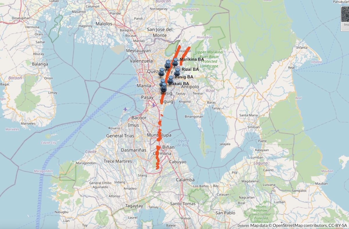
The fault system consists of two primary segments that scientists actively monitor and study. The West Valley Fault spans approximately 100 kilometers, while the East Valley Fault extends about 10 kilometers through Rizal province. Both segments exhibit right-lateral strike-slip movement, meaning the ground on opposite sides of the fault moves horizontally past each other during seismic activity.
Understanding this fault system becomes crucial for residents, local governments, and emergency planners throughout the affected regions. The fault traverses densely populated areas including parts of Metro Manila, making earthquake preparedness and risk assessment vital for public safety. Scientists continue to study the fault’s behavior, create hazard maps, and develop monitoring systems to help communities prepare for potential seismic events.
Overview of the Marikina Valley Fault System
Table of Contents
The Marikina Valley Fault System is a major active fault zone in the Philippines that poses significant earthquake risks to Metro Manila and surrounding areas. This geological feature spans multiple provinces and consists of two primary fault segments with distinct characteristics.
Definition and Terminology
The Marikina Valley Fault System (MVFS) is a dominantly right-lateral strike-slip fault system located on Luzon Island in the Philippines. Scientists also refer to it as the Valley Fault System (VFS).
A strike-slip fault means the ground moves horizontally along the fault line. The “right-lateral” part means if someone stands on one side of the fault, the other side moves to the right during an earthquake.
The fault system consists of two main segments. The West Valley Fault stretches about 100 kilometers long. The East Valley Fault is much shorter at only 10 kilometers long.
Both faults are considered active. This means they have moved recently in geological time and could produce earthquakes in the future.
Historical Background and Naming
The fault system gets its name from the Marikina Valley area where it was first studied extensively. The Marikina River flows through this valley in Metro Manila.
Scientists have found evidence that the West Valley Fault last moved in 1658. This movement created a large earthquake that affected the region.
Research shows the fault moves every 400 to 600 years on average. Based on this pattern, scientists worry about when the next major earthquake might happen.
The fault can generate earthquakes as strong as magnitude 7.2. These powerful quakes would cause serious damage to buildings and infrastructure in Metro Manila.
Geographic Extent and Coverage
The Marikina Valley Fault System extends 135 kilometers across central Luzon. It starts in Dingalan, Aurora in the north and runs southward through several provinces.
The fault passes through Nueva Ecija, Bulacan, and Rizal provinces. It also crosses through Metro Manila, including Quezon City and other urban areas.
The West Valley Fault begins in Doña Remedios, Bulacan and extends south through Cavite to Laguna. The East Valley Fault runs primarily through Rizal province.
This fault system cuts through the eastern part of Metro Manila. Millions of people live and work near these fault lines every day.
The Philippine Institute of Volcanology and Seismology (PHIVOLCS) monitors this fault system closely. They study ground movement and earthquake risks for public safety.
Geological Characteristics and Tectonics
The Marikina Valley Fault System exhibits dominantly dextral strike-slip motion along multiple fault segments. This active fault system operates within the complex tectonic framework where the Philippine Sea Plate and Sunda Plate interact.
Fault Type and Mechanisms
The Marikina Valley Fault System represents a dominantly right-lateral strike-slip fault system. This means the fault blocks move horizontally past each other, with the eastern side moving northward relative to the western side.
The system shows dextral strike-slip motion as its primary mechanism. This type of movement creates horizontal displacement along the fault plane rather than vertical uplift or downdrop.
Scientists have identified variations in both vertical and horizontal displacements along different fault segments. These variations indicate that the fault system experiences complex stress patterns during seismic events.
The strike-slip motion reflects the regional stress field. This stress comes from the ongoing collision and interaction between major tectonic plates in the Philippine region.
Plate Tectonic Setting
The fault system operates within the broader tectonic framework of the Philippines. The region sits at the boundary between the Philippine Sea Plate and the Sunda Plate.
These two major plates create intense tectonic stress as they interact. The Philippine Sea Plate moves westward while the Sunda Plate resists this motion.
This plate interaction generates the regional stress field that drives fault movement. The Marikina Valley Fault System accommodates part of this plate motion through strike-slip displacement.
The fault represents one of several active fault systems in Luzon. It helps distribute the tectonic stress across the island’s complex geological structure.
Fault Displacement and Activity
The fault system contains multiple fault segments with different characteristics. Scientists have identified ten geometric and structural segments along the East and West Valley Faults.
The West Valley Fault extends approximately 100 kilometers. It runs from Bulacan province through Metro Manila down to Cavite and Laguna provinces.
The East Valley Fault measures about 10 kilometers in length. This shorter segment lies within Rizal province.
Recent geological evidence indicates the fault system was active during the Late Pleistocene to Holocene period. This means it has moved within the last 2.6 million years, with continued activity in recent geological time.
The fault poses significant seismic hazards due to its proximity to Manila and surrounding urban areas. Seismic events along this system could generate major earthquakes affecting millions of people.
Major Fault Segments
The Marikina Valley Fault System consists of two primary fault segments that pose significant earthquake risks to Metro Manila and surrounding areas. The West Valley Fault stretches approximately 100 kilometers across multiple provinces, while the East Valley Fault spans about 10 kilometers in Rizal.
West Valley Fault
The West Valley Fault (WVF) represents the larger and more extensive segment of the Marikina Valley Fault System. This fault line extends approximately 100 kilometers through several provinces in Luzon.
The WVF runs from Bulacan in the north, passes through Metro Manila, and continues south through Cavite to Laguna. This extensive reach makes it a major concern for earthquake preparedness in the region.
The fault displays dextral strike-slip motion, meaning the ground on opposite sides of the fault moves horizontally past each other. This type of movement has been the dominant characteristic during recent geological activity.
The West Valley Fault passes through densely populated urban areas. This location increases the potential impact of any seismic activity along this fault segment.
Scientists have identified vertical slip components in the northern part of the fault. These vertical movements contributed to the formation of a basin between the eastern and western fault segments.
East Valley Fault
The East Valley Fault (EVF) serves as the shorter but equally important segment of the Marikina Valley Fault System. This fault line measures approximately 10 kilometers in length and is located primarily in Rizal province.
Like the West Valley Fault, the EVF exhibits dextral strike-slip motion as its primary type of movement. This horizontal sliding motion characterizes the fault’s recent geological behavior.
The East Valley Fault shows significant vertical slip components in its southernmost segment, particularly in the Talim area. Researchers attribute these vertical movements to volcanism-related extension in the region.
Despite its shorter length compared to the WVF, the East Valley Fault still presents considerable seismic hazards. Its proximity to populated areas makes it an important focus for earthquake risk assessment.
The EVF works together with the West Valley Fault to form the complete Marikina Valley Fault System. Both segments contribute to the overall seismic risk profile of the greater Manila area.
Regions and Cities Traversed by the Fault System
The Marikina Valley Fault System spans approximately 100 kilometers from Bulacan province in the north to Laguna province in the south. The fault cuts through densely populated areas of Metro Manila and several surrounding provinces.
Metro Manila Areas
The West Valley Fault crosses through six major cities in Metro Manila. These urban areas face significant earthquake risks due to their dense populations and infrastructure.
Quezon City serves as the northernmost Metro Manila area affected by the fault system. The fault line passes through multiple barangays in this highly populated city.
Marikina sits directly along the fault trace, making it one of the most vulnerable cities. The Marikina River valley follows much of the fault’s path through this area.
Pasig City experiences fault movement in its western sections. The fault continues south from Marikina into residential and commercial districts.
Makati City has portions of the fault running through business and residential zones. This creates concerns for the central business district nearby.
Taguig City contains fault segments in its northern areas. The fault affects both residential neighborhoods and developing commercial zones.
Muntinlupa City marks the southern boundary of Metro Manila’s fault exposure. The fault continues south from this city into Laguna province.
Bulacan and Rizal Province
The fault system begins in Bulacan province and affects parts of Rizal province east of Metro Manila.
Doña Remedios Trinidad in Bulacan marks the northern starting point of the West Valley Fault. This municipality sits at the fault’s origin point.
San Jose del Monte City and Norzagaray in Bulacan also experience fault activity. These areas connect the northern fault segments to Metro Manila.
Rizal province contains the East Valley Fault segment, which runs parallel to the West Valley Fault. Rodriguez and San Mateo are key municipalities affected by fault movement in this province.
The East Valley Fault spans approximately 10 kilometers through Rizal. This shorter segment still poses earthquake risks to local communities.
Both provinces contain mountainous terrain that influences how the fault moves. The geological conditions affect earthquake intensity and ground shaking patterns.
Laguna and Cavite
The southern portion of the fault system extends through Laguna and Cavite provinces before ending near Canlubang.
Laguna province contains multiple cities along the fault path. San Pedro, Biñan, Cabuyao, Calamba, and Sta. Rosa all sit near or on the fault line.
These Laguna cities have grown rapidly in recent decades. Urban development along the fault increases earthquake vulnerability for thousands of residents.
Cavite province experiences fault activity in its eastern municipalities. Carmona and Silang contain fault segments that connect to the Laguna portion.
The fault system terminates near Canlubang in Laguna province. This southern endpoint marks the complete 100-kilometer span of the West Valley Fault.
Industrial and residential developments in both provinces continue expanding near fault areas. Proper construction standards become critical for earthquake safety in these growing communities.
Earthquake Hazards and Seismic Risks
The Marikina Valley Fault System poses serious earthquake threats to Metro Manila and nearby areas. Scientists predict a major magnitude 7.2 earthquake could strike the region, causing widespread damage and casualties.
Historical and Recent Earthquakes
The Marikina Valley Fault System has produced several earthquakes throughout history. The fault system shows active movement during recent times.
Recent studies focus on earthquake activity near Metro Manila. The 2019 magnitude 6.1 Castillejos earthquake in Zambales reminded people about seismic risks in the region.
Scientists study past earthquakes to understand the fault’s behavior. The 1976 Moro Gulf earthquake serves as an important example of major seismic events in the Philippines.
The Philippine Institute of Volcanology and Seismology (PHIVOLCS) tracks earthquake activity along the fault system. They record small earthquakes and ground movements regularly.
Potential for Major Seismic Events
Experts consider the Valley Fault System a serious threat for large-scale earthquakes. The fault system could release significant energy that has built up over time.
PHIVOLCS identifies the West Valley Fault as particularly dangerous. This 100-kilometer fault runs from Bulacan through Metro Manila to Laguna.
The East Valley Fault in Rizal spans 10 kilometers. Both faults can produce destructive earthquakes that would affect millions of people.
Scientists observe aseismic creep along parts of the West Valley Fault. This slow ground movement shows the fault remains active and under stress.
Magnitude 7.2 Earthquake Scenario
PHIVOLCS calls the predicted magnitude 7.2 earthquake “The Big One.” This scenario represents the worst-case earthquake the fault system could produce.
The magnitude 7.2 earthquake would cause severe damage across Metro Manila. Buildings, bridges, and roads would suffer extensive destruction.
Scientists estimate thousands of casualties from such an earthquake. The event would create massive economic losses in the country’s business center.
Emergency planners use this scenario to prepare response strategies. The earthquake would affect water systems, power grids, and transportation networks throughout the region.
Hazard Mapping, Monitoring, and Preparedness
PHIVOLCS creates detailed maps showing earthquake zones and fault lines to help people understand risks in their areas. The agency monitors ground movement and works with local governments to prepare communities for possible earthquakes.
Fault Mapping and Zoning
PHIVOLCS produces earthquake hazard maps that show where active faults run through communities. These maps help people see if they live near dangerous fault lines.
The Valley Fault System Atlas gives the public exact information about fault locations. This tool helps communities prepare for ground rupture during earthquakes.
PHIVOLCS also created the FaultFinder system. This online tool lets people check if their homes or businesses sit on active fault zones.
The maps show both the West Valley Fault and East Valley Fault segments. These faults pose major earthquake risks to Metro Manila and nearby areas.
Some provinces may not have hazard maps yet. This means either no major hazards exist there or mapping work continues.
PHIVOLCS Monitoring Initiatives
The Philippine Institute of Volcanology and Seismology tracks earthquake activity along the fault system. Scientists study how the faults move and change over time.
Research shows the Marikina Valley Fault System has dextral strike-slip movement. This means the fault blocks slide past each other sideways during earthquakes.
PHIVOLCS scientists examine recent ground features along the fault lines. They look for signs of past earthquakes and predict future risks.
The agency continuously improves hazard information accuracy. New data helps create better maps and warnings for the public.
Monitoring equipment records ground movement and seismic activity. This data helps scientists understand when earthquakes might happen.
Disaster Preparedness and Response
PHIVOLCS works to reduce earthquake dangers through community education. The agency teaches people how to prepare for ground rupture and shaking.
The Metro Manila Development Authority coordinates with PHIVOLCS on earthquake planning. They develop response strategies for the dense urban population.
Communities near fault lines receive special attention for preparedness training. Local governments use fault maps to plan safer building locations.
Emergency response teams practice earthquake scenarios. These drills help responders know what to do when real earthquakes strike.
Public awareness programs teach residents about earthquake safety. People learn to identify fault zones and protect their families during disasters.
The hazard maps help city planners avoid building important structures on active faults. This reduces damage when earthquakes occur.
Frequently Asked Questions
The Marikina Valley Fault System poses significant earthquake risks to millions of people in Metro Manila and surrounding areas. Understanding the potential impacts, safety measures, and government mitigation efforts helps residents prepare for possible seismic events.
What are the potential impacts of an earthquake along the Marikina Valley Fault System on Metro Manila?
A major earthquake along the Marikina Valley Fault System could cause severe damage to Metro Manila’s buildings and infrastructure. The fault runs directly through highly populated areas of the capital region.
Ground shaking would likely damage older buildings that lack proper earthquake-resistant construction. Many roads, bridges, and utilities could fail during a strong earthquake.
The dense population of Metro Manila means millions of people could be affected. Emergency services might struggle to respond quickly due to damaged transportation networks.
Economic impacts would be significant. Business operations could stop for weeks or months while buildings and infrastructure get repaired.
How often does significant seismic activity occur along the Marikina Valley Fault System?
The Marikina Valley Fault System has been relatively quiet in recent recorded history. Scientists believe the fault last moved during a major earthquake several hundred years ago.
Geological evidence shows the fault has been active during the Late Pleistocene to Holocene periods. This indicates the fault can produce earthquakes but at long intervals between major events.
The West Valley Fault, which is 100 kilometers long, poses the greatest concern. Its length suggests it could generate a strong earthquake when it eventually moves.
Scientists cannot predict exactly when the next major earthquake will occur. They focus on studying the fault’s behavior and preparing communities for future seismic activity.
What are the recommended safety measures for residents living near the Marikina Valley Fault System?
Residents should secure heavy furniture and objects that could fall during shaking. Bookcases, water heaters, and televisions need proper anchoring to walls.
Families must create emergency plans that include meeting points and communication methods. Each household should store emergency supplies like water, food, and first aid materials for at least three days.
People should learn how to turn off gas, water, and electricity in their homes. Knowing the locations of these shut-off valves prevents additional hazards after an earthquake.
Regular earthquake drills help residents practice “Drop, Cover, and Hold On” techniques. Schools and workplaces should conduct these drills frequently.
What recent studies have been conducted on the Marikina Valley Fault System, and what are their findings?
Recent geological studies have identified neotectonic features along the fault system. These studies show the fault exhibits dominantly dextral strike-slip motion during its most recent activity.
Research has mapped variations in vertical and horizontal displacements along different fault segments. This helps scientists understand how the fault moves and where stress builds up.
Scientists have studied both the East Valley Fault and West Valley Fault segments. The West Valley Fault receives more attention due to its 100-kilometer length compared to the East Valley Fault’s 10-kilometer length.
Ground-penetrating surveys and geological mapping continue to reveal new details about the fault’s structure. These studies help improve earthquake hazard assessments for the region.
How is the Philippine government mitigating the risks associated with the Marikina Valley Fault System?
The government has implemented building codes that require earthquake-resistant construction in high-risk areas. New structures must meet specific engineering standards to withstand ground shaking.
Public education campaigns teach citizens about earthquake preparedness and safety measures. Government agencies distribute information about emergency planning and response procedures.
Emergency response teams receive training for large-scale earthquake scenarios. Fire departments, medical services, and rescue units practice coordinated disaster response.
The government supports scientific research to better understand the fault system. This includes funding geological studies and seismic monitoring programs.
What should individuals do to prepare for a potential earthquake caused by the Marikina Valley Fault System?
Individuals should create comprehensive emergency kits with supplies for at least 72 hours. These kits must include water, non-perishable food, flashlights, batteries, and medications.
People need to identify safe spots in their homes where they can take cover during shaking. Interior doorways and sturdy desks provide better protection than windows or tall furniture.
Families should establish communication plans and designate out-of-area contact persons. Local phone lines often fail during disasters, but long-distance calls may work.
Regular participation in earthquake drills builds muscle memory for proper responses. Practicing these actions helps people react correctly when real earthquakes occur.
Follow us on Facebook and Twitter.
Read: Filinvest at 70: Giving Back through Loaves X Fish